Introduction to DGGS: A Guide to Discrete Global Grid Systems
If you have worked with geospatial data covering large areas, you’ve probably have to deal with projections, having to represent the globe on a plane surface and this usually inevitably introduces distortion and stretching specially when you move north or south of the equator. This distortion fundamentally changes the area of your map pixels represents
As a result, the stretching physically changes the area that your map pixels represent. So imagine in a situation where you have to perform analysis at a global scale, and you need to combine multiple layers, say temperature, orest cover, precipitation, and more. These layers would typically have to be stacked up into some data cubes and for this layer to be comparable, their underlying pixels have to be perfectly lined and critically represent a consistent area across the globe. This brings us to Discrete Global Grid Systems (DGGS) - a different approach to organizing and analysing geospatial data.
What is DGGS
DGGS provides a very unique way of defining a geospatial reverence system. It works by tessellating the globe, that means sub-dividing it into a huge number of small grid cells with each having a unique identifier and at different resolutions. Think about it as covering a basketball with small patches, but instead of dividing the grid on a flat surface or screen, the grids are defined on the sphere itself in 3D space.
At the core of the DGGS are cells - the smallest unit of a DGGS which defines how the earth is divided. There are different cell types and the most widely used shapes are triangles, squares and hexagons, each having its own advantages and limitations, with hexagons being the most widely used, thanks to popular DGGS like the Uber H3.
DGGS are powerful not only because they offer a better spatial reverence system but also because it can handle different data operations, from storing and managing, to exploration and visualisation of large geospatial datasets by utilizing efficient indexing schemes, making operation vaster and more effective. It also supports the integration of different data formats, both raster and vector into a unified geospatial data model.
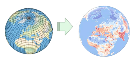 Transformation from a traditional projected coordinate system grid to a Discrete Global Grid System (DGGS) - Luik, I., Kmoch, A., Chan, W. T., & Chrapkiewicz, K. M. (2025)
Benefits of DGGS vs Traditional method
While traditional latitude-longitude systems and map protection are useful and have served the are plagued with some issues. Some of which include distortions that vary by location, pixels that might map to different physical areas depending on where your data was collected and difficulty integrating data from different sources at different resolutions. How does DGGS address this?
- In DGGS, data is stored in fixed, aligned cells, which makes it faster to find based on location compared to layered systems. By using discrete cells instead of continuous points, it reduces uncertainty and also allows consistent observation of the same area over time
- While the traditional system requires separate indexing, storage and query methods for vector and raster, DGGS provides a more uniform data model that supports the transformation and integration of geospatial data from various sources.
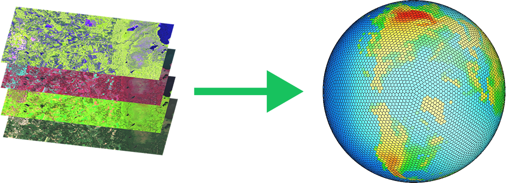 Integrating data data into a single, seamless, and analysis-ready global grid
Types of DGGS
DGGS can be classified bayside on different design considerations. They can be hierarchical or non-hierarchical, they can also be classified based on the geometry of the tessellation used to segment the globe. As earlier mentioned, they come in different flavors which can be either triangles, hexagons, or rectangles.
There are different implementations of DGGS, some include
- Uber H3 is perhaps the most popular and first commercial hexagon-based DGGS developed by Uber for their location intelligence needs .
- Google S2 which is the backbone of popular products like Google Maps and Earth.
- HEALPix (Hierarchical Equal Area isoLatitude Pixelation), and its relative rHEALPix originally developed for astrophysics but now adopted in Earth observation for its equal area property
- IGEO7 which is also a hexagonal DGGS announced at the AGILE conference. It uses cells of equal area for all zones, making it a true equal-area DGGS, making it suitable for geospatial analysis.
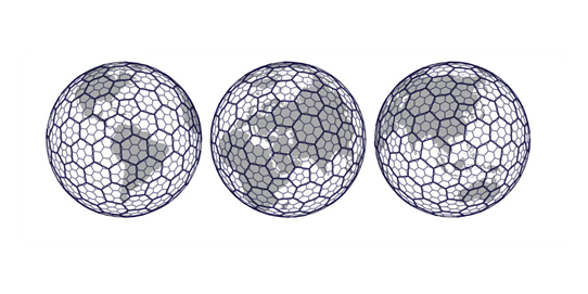 Uber’s Hexagonal Hierarchical Spatial Index (Uber Blog. 2018, June 27)
Applications of DGGS
DGGS is already being applicated in different areas, some of which include:
Suitability analysis
Since DGGS is an equal area reverence system, it provides that needed consistent framework for evaluating multiple criteria across different regions.
Logistics and Transportation
Uber H3 is a good example of this where it is used by Uber to deliver optimization, service area analysis, etc, across cities worldwide. Another, area where DGGS has been used in the HyTruck project, where it is used to optime hydrogen recycling station placement and route planning, as well as finding these stations by looking up cell IDs
Climate and Flood modelling
Global climate models leverage DGGS vor their simulation, thanks to the equal-area grid cells of DGGS which are crucial for accuracy, Additionally, it has been used in modelling flood risk under various climate scenarios.
Getting started with DGGS
If you are curious about how to get started with DGGS, there are growing resources that are available. The Open Geospatial Consortium OGC, which provides standards for sharing geospatial data, also provides specifications for DGGS that ensure interoperability between existing and future DGGS implementations. Additionally, there are many open-source tools and platforms like the one built at Geolynx that can help you explore the power of DGGS, without needing to build everything from scratch.
DGGS is not just a new technology, it is fast changing the way we think about how we represent and analyze data at a global scale. As the volume of geospatial data continues to grow and the need for global analysis increases, having a consistent framework to organize and analyse these geospatial data has also become important. DGGS offer a promising perceptive that is worth exploring and thanks to Open Standards and a growing ecosystem it is becoming a more accessible and power way to work with geospatial data.
Learn more
OGC DGGS API implementation. - A FastAPI Python implementation of DGGS
References
- Brodsky, I. (2018). H3: Uber’s Hexagonal Hierarchical Spatial Index. Uber Engineering Blog. Retrieved from https://www.uber.com/en-EE/blog/h3/
- Esri Community. (2023, June 24). Introduction to Discrete Global Grid System (DGGS). Esri Canada Centre of Excellence. Retrieved from https://ecce.esri.ca/blog/2023/06/24/introduction-to-discrete-global-grid-system-dggs/
- Kmoch, A., Sahr, K., Chan, W. T., and Uuemaa, E.: IGEO7: A new hierarchically indexed hexagonal equal-area discrete global grid system, AGILE GIScience Ser., 6, 32, https://doi.org/10.5194/agile-giss-6-32-2025, 2025
- Kmoch, A., Vasilyev, I., Virro, H., & Uuemaa, E. (2022). Area and shape distortions in open-source discrete global grid systems. Big Earth Data, 6(3), 256–275. https://doi.org/10.1080/20964471.2022.2094926
- Li, M., McGrath, H., & Stefanakis, E. (2022). Multi-Scale Flood Mapping under Climate Change Scenarios in Hexagonal Discrete Global Grids. ISPRS International Journal of Geo-Information, 11(12), 627. https://doi.org/10.3390/ijgi11120627
- Li, M., & Stefanakis, E. (2020). Geospatial Operations of Discrete Global Grid Systems—a Comparison with Traditional GIS. Journal of Geovisualization and Spatial Analysis, 4(26). https://doi.org/10.1007/s41651-020-00066-3
- Luik, I., Kmoch, A., Chan, W. T., & Chrapkiewicz, K. M. (2025, September 24). Research seminar on Discrete Global Grid Systems (DGGS). [Seminar Presentation].